Puerto Princesa Subterranean River National Park
A protected area with a major underground river and cave system.

The Puerto Princesa Subterranean River National Park is a protected area in the Philippines, located in the Saint Paul Mountain Range on the western coast of the island of Palawan, about 80 kilometers north of the city of Puerto Princesa. It contains the Puerto Princesa Subterranean River, also known as the Puerto Princesa Underground River, which is widely recognized as the longest navigable underground river in the world.
- location
- Saint Paul Mountain Range, Palawan, Philippines
- area_type
- Protected area and national park
- underground_river_length
- 8.2 km (5.1 mi)
Lore & Background
The park features the Puerto Princesa Subterranean River, an 8.2 km underground section of the Cabayugan River that winds through a cave system before flowing into the South China Sea. Tidal influence extends only a few kilometers inside the cave, creating a stratified water column, though this disappears during heavy rain. The river is navigable by boat up to 4.3 km from the sea.
Reader's Guide
The park is a major tourist destination, mostly accessed through road trips to the seaside village of Sabang, from where visitors take bangkas (kayaks) to the park.
Did You Know?
- The Puerto Princesa Subterranean River is the longest navigable underground river in the world.
- The park contains a diverse range of forest types, including mangrove and montane forest.
- Nine species of bat and two species of swiftlet are found in the cave.
Geography & Hydrology
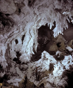
The Puerto Princesa Subterranean River carves its path through a limestone karst landscape on Palawan's western coast, threading an 8.2-kilometer underground stretch of the Cabayugan River before emptying directly into the South China Sea. The surrounding cave network spans at least 32 kilometers, and within it the river creates a remarkable hydrological phenomenon: saltwater from the sea pushes inland for roughly six kilometers, meeting freshwater in a stratified column where the fresh upper layer is merely a few centimeters thick. During periods of heavy rainfall, flooding disrupts this delicate layering by sweeping the seawater out of the system. Boats can navigate approximately 4.3 kilometers from the sea into the cave. Among the most striking features is Italian's Chamber, a vast room stretching 360 meters in length with an estimated volume of 2.5 million square meters, making it one of the largest known cave rooms on Earth. The walls and ceilings are adorned with extensive stalactite and stalagmite formations. Until a comparable underground river was identified in Mexico's Yucatán Peninsula in 2007, this waterway held the distinction of being the longest subterranean river in the world; it now ranks as the second-longest.
Biodiversity & Ecosystem
The park encompasses a complete mountain-to-sea gradient, housing some of the most significant forests in all of Asia. Thirteen distinct forest types characteristic of tropical Asia are represented, ranging from montane and lowland evergreen rainforests to mangrove swamps and beach forests. Researchers have catalogued more than 800 plant species spanning 300 genera and 100 families, including at least 295 tree species dominated by dipterocarps such as dao, ipil, dita, amugis, and apitong. The animal community is equally impressive. Of the 252 bird species documented across Palawan, 165 have been recorded within the park boundaries, accounting for 67 percent of the island's avifauna and all fifteen endemic species. Notable residents include the blue-naped parrot, Tabon scrub fowl, hill myna, Palawan hornbill, and white-breasted sea eagle. Approximately thirty mammal species have been observed, including the long-tailed macaque, Palawan bearded pig, bearcat, and Palawan porcupine. Nineteen reptile species (eight endemic), ten amphibians, nine bat species, and two swiftlet species also call the caves and forests home. In the coastal waters, the sea cow and hawksbill sea turtle feed near the shoreline.
Discovery & Exploration
For decades, the full extent of the underground river remained unknown. In 2010, a team of environmentalists and geologists made a remarkable finding: the subterranean river possesses a second floor, meaning small waterfalls cascade within the cave itself. Their expedition also uncovered a vast cave dome rising 300 meters above the water, additional rock formations, colonies of large bats, a deep water hole in the river, further river channels, and yet another deep cave. Marine creatures were also identified in these newly explored zones. Despite these breakthroughs, the deepest reaches of the river remain effectively inaccessible to explorers because oxygen levels drop to dangerously low concentrations, making prolonged submersion nearly impossible. The park sits within the Saint Paul Mountain Range on Palawan's western coast, roughly 80 kilometers north of the city of Puerto Princesa. Since 1992, the city government has been responsible for managing and protecting the area, balancing the demands of growing tourism with the preservation of this fragile subterranean ecosystem.
International Recognition & Legacy
The park's global standing was cemented on December 4, 1999, when UNESCO inscribed it as a World Heritage Site, recognizing its outstanding universal value. In 2012, it earned two further distinctions: designation as a Ramsar Wetland Site and selection as one of the New 7 Wonders of Nature. The competition journey became a source of national pride. The river entered as the Philippine candidate, topped the first round of voting, and advanced to the 28 finalists on July 29, 2011. Mayor Edward S. Hagedorn publicly thanked supporters after that milestone. On November 11, 2011, it was provisionally named among the wonders, joining the Amazon rainforest, Halong Bay, Iguazu Falls, Jeju Island, Komodo Island, and Table Mountain. The official confirmation came on January 28, 2012, when Malacañang expressed elation, noting that Filipinos from all walks of life had devoted time, energy, and resources to the campaign. Today, the site draws visitors who travel by road to the seaside village of Sabang, where small bangkas (kayaks) carry them into the cave mouth, making the experience both a journey and a living connection to the natural world.
Frequently Asked Questions
Who is Puerto Princesa Subterranean River National Park?
It is a protected national park tucked into the Saint Paul Mountain Range along Palawan's western coast, roughly 80 km north of Puerto Princesa city. Its headline feature is a subterranean river that is widely cited as the longest navigable underground waterway on the planet.
What are Puerto Princesa Subterranean River National Park's powers or role?
The park's core "ability" is its vast limestone cave-and-river system, which lets tour boats glide deep through dark, stalactite-lined passages. It also serves as a Ramsar-recognized wetland and a shelter for the surrounding karst biodiversity.
Why is Puerto Princesa Subterranean River National Park important?
It protects one of the most spectacular karst and cave landscapes on Earth while preserving the wetlands and forests that feed the underground river. Holding UNESCO World Heritage, New 7 Wonders of Nature, and Ramsar Wetland designations simultaneously makes it a uniquely significant conservation site.
Where can fans actually visit Puerto Princesa Subterranean River National Park?
The park is located in the Saint Paul Mountain Range on the western shore of Palawan, Philippines, about 80 kilometers north of Puerto Princesa city. Visitors typically reach the river by boat from the park's designated landing area.
More in Caves And Karst Formations 25-26
Elsewhere in the Caves And Karst Formations universe
Spotted an error? Know more?
This is a living reference — every entry is fact-audited, and reader corrections feed straight into our audit queue. Suggest an edit · See this site's audit record